Apr 23 2018
Groundwater modelling misses the mark
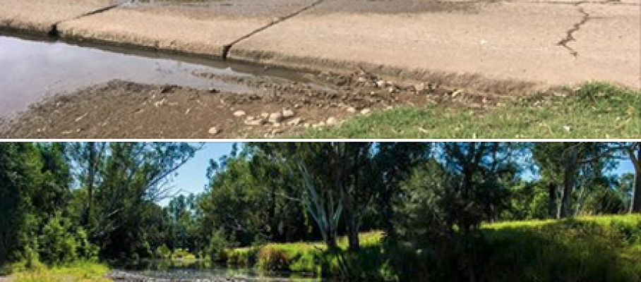
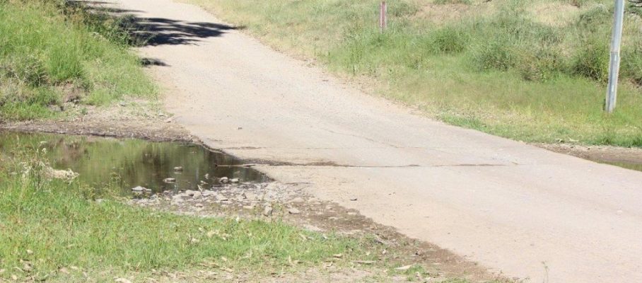
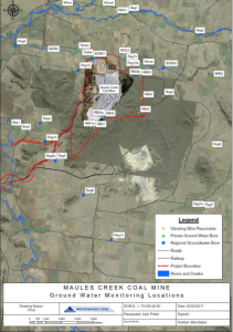
Now that water supplies in the Maules Creek area are running low, residents are questioning the impact of mining and the ability to improve water levels given the existing baseline data, the monitoring of mine water usage and the state governments regulatory processes.
The Maules Creek coal mine was approved with a series of conditions that required the development of groundwater management plans, the validation of computer modelling, the development of adaptive management triggers and response plans, and self regulation by the mine itself.
It is hardly a recipe for the early identification and resolution of problems without strong government oversight. Based on past experience with noise and dust, mine self-regulation is unlikely to work should anything threaten the mine’s operations and returns to it’s shareholders.
Unfortunately, the government itself is conflicted. At the same time as the mine was being approved and constructed, the Department of Water was being systematically gutted, with the removal of operational staff, technical experts and middle management, leaving only the licensing division and the politically connected senior management to “supervise” any complaints and then manage the fallout.
Now, as water levels decline, the regulatory regime will come under the microscope and it is important to note that the potential for groundwater impacts were raised strongly prior to the projects approval.
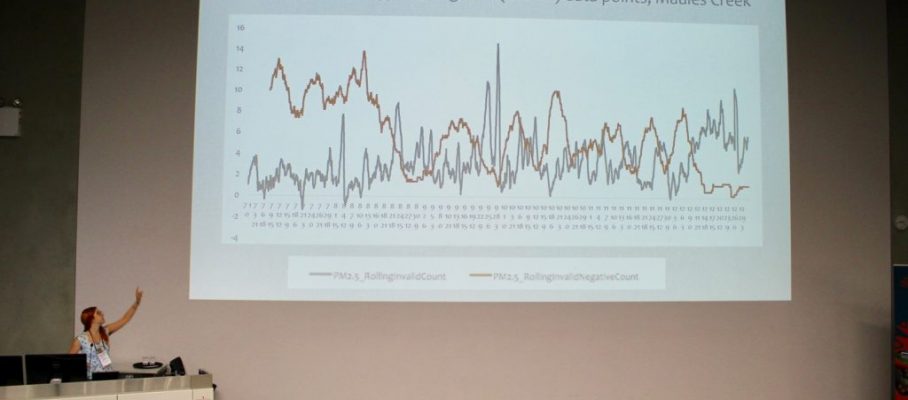
The Peer Reviewer of the Maules Creek coal mine groundwater modelling had serious doubts back in 2012.
“Using the MDBC guidelines checklist, the modelling is found to be deficient and/or lacking in the areas of calibration, verification, sensitivity analyses and uncertainty analyses – each to varying degrees.”
“The primary risks of impact being assessed are associated with the alluvial systems yet the connection between the alluvial and bedrock systems in the calibrated model are not assessed to the previous studies and conceptual model to provide the reader with any confidence the model is replicating reality.“
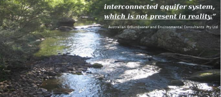
In fact groundwater specialists engaged by Maules Creek coal said exactly that on Page 62 of their Groundwater Impact Assessment;
“The model therefore simulates a continuous hydraulically interconnected aquifer system, which is not present in reality.”
Its inconceivable that the model didn’t represent reality raised no red flags for the miners, the Dept, the PAC and the regulators. The company simply paid another expert, as did the PAC, to confirm that everything was OK.
The Peer Reviewer for the local community gave a foretaste of the situation at the Werris Creek coal mine (and potentially at the Maules Creek mine) whereby the miner points to the results of their deficient theoretical groundwater model while blaming “the drought” for dry bores, while the mine pits are flooded with water. The Peer Reviewer lamented back in 2012 that the Groundwater Impact Assessment did nothing to assist with accountability should a groundwater problem arise.
“A clear method for identifying mining related loss of well yields from background yield losses should be defined up front to eliminate any confusion or difficulties after the fact.”
However it is this same deficient theoretical model which is now being use to regulate the mine 5 years later and it is time that the assumptions that were used are tested.


Apr 27 2018
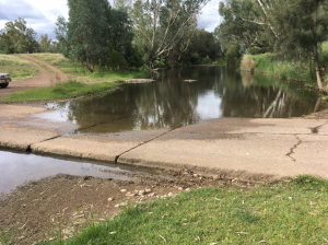
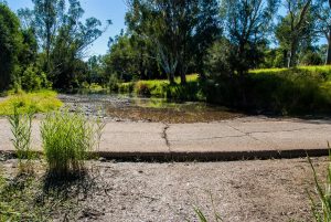
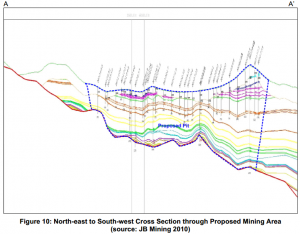
Aerial photos of Maules Creek mine pit lake
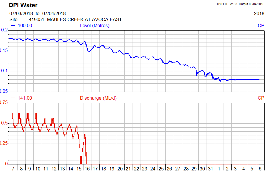
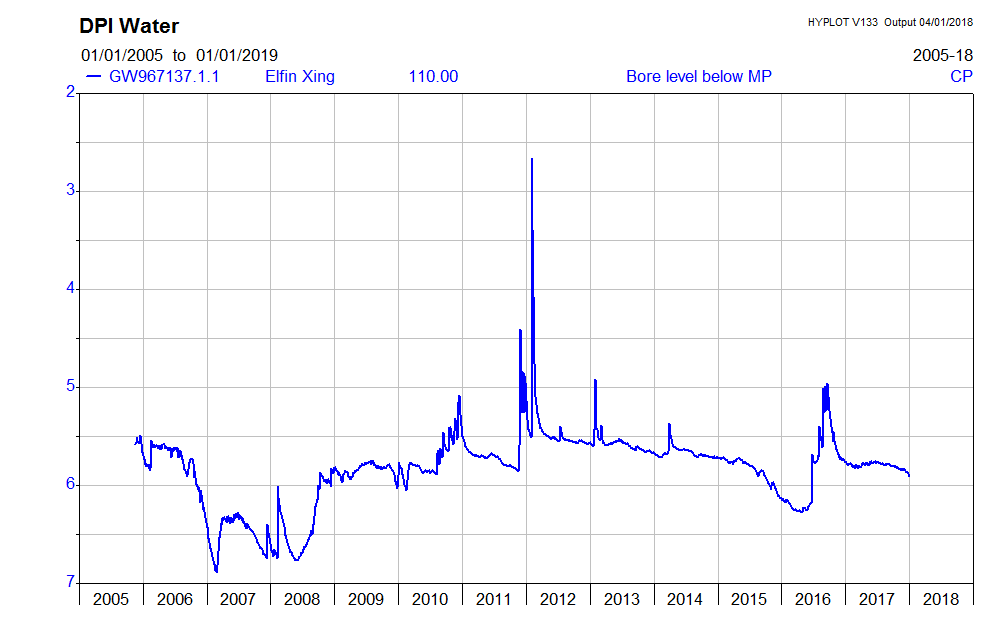
The above aerial photo from the 14.4.2018 with the 300 tonne dump truck in the foreground shows the sheer amount of water in the Maules Creek mine pit. It’s deeply concerning given that the Tarrawonga and Boggabri coal mines are both dry and that the original EIS modelling estimated only 36 ML of groundwater would have flowed into the Maules Creek coal pit over the last 12 months.
Without transparent data to the contrary, this raises the significant prospect of connectivity of the coal seams to the Maules Creek alluvial aquifer.
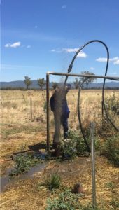
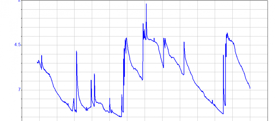
De-watering Pump
In order to drill, blast and excavate the coal, the mine is systematically de-watering the coal seams.
The de-watering pump in the Maules Creek coal mine can be seen in this short video. According to the 2014 Water Management Plan the discharge from this pump ends up in the Mine Water Dam to be used for dust suppression.
The question for local people is – is the mine only de-watering the coal seams?
One 100 mm pump such as those shown here could move a lot of water if operated 24 x 7, 365 days per year. A 150 mm pump could move much more.
With pit pumping conditions similar to those at the Maules Creek coal mine (70 m head and 800 m of lay flat hose), according to suppliers, a 100 mm pump could lift 30 – 50 litres per second, 2.5 – 4.0 ML per day or 946 – 1,575 ML per year.
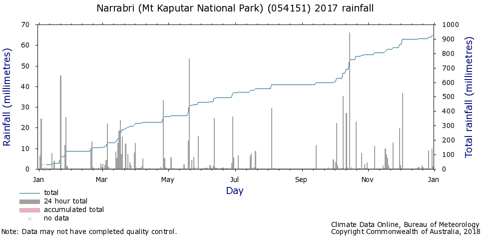
The last few months have been dry (with approx 40% of average rainfall)1 and the full pumping capacity should not be needed at the Maules Creek coal mine to manage pit inflows.
Groundwater Modelling
The groundwater consultants (AGE) estimated in the Groundwater Impact Assessment very minor pit inflows or “seepage” when they simulated over 30 years the average groundwater inflows to the Maules Creek and adjacent mines.
Year 1 – 5 estimates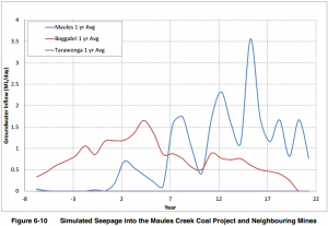
(See Fig 6.10 Maules Creek coal mine Water Management Plan.)
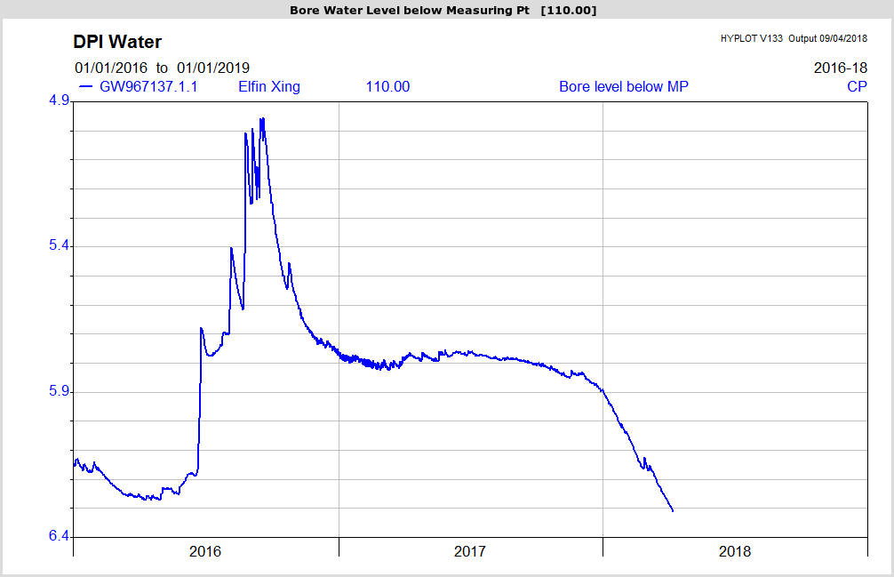
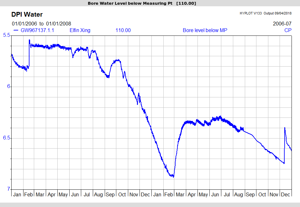
However given the current dry patch, the lack of runoff and the significant volume of water in the pit, how realistic is the AGE estimate of 36 ML “seepage”?
Anecdotal evidence is that this pump has been running for much longer than 1 hour per day over the last 14 months. If true, this would indicate a substantial variation from what the State Government has approved. Without any transparent data to the contrary it is time for the regulators to act.
Regulation
The estimated pit inflows to the Maules Creek mine are the basis for the monitoring and the Adaptive Management requirements of the project approval. If monitoring of the groundwater inflow shows adverse groundwater impacts then this should trigger a management response as required by the 2014 Water Management Plan section 6.3.4;
“Should monitoring results be outside of the predictions made within the Groundwater Impact Assessment (as summarised above) and indicate a substantial variation beyond the trigger levels presented, then an investigation into the data will be implemented to confirm the reason for the variation and to implement the relevant actions. The process of investigation that will be implemented is described further in Section 7.0.”
This ties vaguely to Schedule 5 of the project approval which requires notification within 7 days;
“Incident Reporting
Schedule 3 Section 40 of the project approval referrd to in the Adaptive Management section of Schedule 5 says;
By MCCC • Uncategorized •